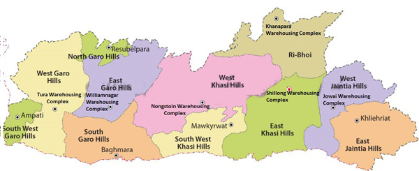
Shillong, Nov 9: Come Wednesday and Meghalaya will have one more district, taking the total tally of districts in the state to 12. The 12th district, named Eastern West Khasi Hills, comes as part of the 50th year of statehood celebrations.
As we eagerly wait for November 10, 2021 to come, here is a look back at the annals of history to trace the formation of various districts in the State over the course of 49 years, namely, West Jaintia Hills (Jowai), East Jaintia Hills (Khliehriat), East Khasi Hills (Shillong), West Khasi Hills (Nongstoin), South West Khasi Hills (Mawkyrwat), Ri-Bhoi (Nongpoh), North Garo Hills (Resubelpara), East Garo Hills (Williamnagar), South Garo Hills (Baghmara), West Garo Hills (Tura), and South West Garo Hills (Ampati).
Notably, Meghalaya was carved out of Assam on January 21, 1972, with just two districts of the United Khasi Hills and Jaintia Hills, and the Garo Hills.
East Jaintia Hills
The East Jaintia Hills was created by bifurcation of the erstwhile Jaintia Hills. The Jaintia Hills district was created on February 22, 1972 with its headquarters at Jowai, making it the first district to be created since the State’s formation.
The Jaintia Hills district was bifurcated on July 31, 2012 to create East Jaintia Hills with its Headquarters at Khliehriat.
Khliehriat, the district headquarters, was created as an administrative unit on August 14, 1976 and was upgraded to a civil sub division on May 27, 1982 before finally becoming the district headquarters.
West Jaintia Hills
West Jaintia Hills District came into existence on July 31, 2012 with the bifurcation of Jaintia Hills, with its headquarters at Jowai. Jowai was already the headquarters of the erstwhile Jaintia Hills; hence, new infrastructure wasn’t required to make the new district functional.
Jowai is the host of all the heads of important governmental offices and establishments, educational institutions, hospitals, banking institutions, etc.
East Khasi Hills district
The East Khasi Hills district was carved out of the Khasi Hills on October 28, 1976 with its headquarters at Shillong. It is also the most populous district of the state. The District is mostly hilly with deep gorges and ravines on the southern portion.
Shillong was made the civil station of the Khasi and Jaintia Hills in 1864 by the British, later becoming headquarters of Assam in 1874. It remained the capital of undivided Assam until the creation of Meghalaya on January 21, 1972, when Shillong became the capital of Meghalaya.
Shillong is a hill station and it’s said that the rolling hills around the town reminded the British of Scotland, hence, they would also refer to it as the “Scotland of the East”. Shillong peak, 10 km from the city, offers a panoramic view of the scenic country side and is also the highest point in the district as well as in the State.
Ri-Bhoi district
The Ri-Bhoi district was formed by the further division of East Khasi Hills district on June 4, 1992, with its headquarters located at Nongpoh.
It has a hilly terrain, and a large part of the area is covered with forests. The Ri-Bhoi district is known for its pineapples and is the largest producer of pineapples in the state.
West Khasi Hills district
The West Khasi Hills district was carved out of Khasi Hills District on October 28, 1976. The district headquarters are located at Nongstoin.
It spreads through the heart of the state running high with plateau ranges and low with rich plain lands.
South West Khasi Hills district
The South West Khasi Hills district was carved out of the West Khasi Hills district on August 3, 2012. The district headquarters is located at Mawkyrwat.
Prior to becoming a district, Mawkyrwat Civil Sub-Division was a Civil Sub Division since June 26, 1982.
East Garo Hills district
The East Garo Hills district was formed on October 22, 1976 with the bifurcation of Garo Hills into two districts; the other district being the West Garo Hills. Its District Headquarters are at Williamnagar, earlier known as Simsangiri.
West Garo Hills district
The West Garo Hills district lies in the western part of the state and its district headquarters are located at Tura. It was formed on October 22, 1976 with the bifurcation of Garo Hills.
South Garo Hills district
The South Garo Hills district came into existence on June 18, 1992 after the division of the West Garo Hills district. The district headquarters are at Baghmara. The district is hilly with difficult terrain.
South West Garo Hills
South West Garo Hills came into existence on August 7, 2012 with the upgradation of Ampati Civil Sub-Division. Ampati now serves as the district headquarters.
North Garo Hills
The North Garo Hills district was carved out of the East Garo Hills district on July 27, 2012, with the upgradation of Resubelpara Civil Sub division. Resubelpara Town is the Headquarter of the District.
The Government of Assam established Resubelpara Development Block with Resubelpara as its Head Quarter on October 2, 1952. The Government of Meghalaya declared Resubelpara as an Administrative Unit in 1976.
It was upgraded into a full fledged Civil Sub-Division on April 30, 1982. The State Government declared Resubelpara as a town on the November 29, 1995 and also created a Municipal Board on the February 28, 1997.


