

Sikkim, Oct 5: A flash flood after a cloudburst in Sikkim has caused widespread damage and devastation in the hilly state. The torrential rainfall resulted in overflowing rivers and landslides, washing away homes, roads, and bridges.
The flash floods originated from the lake that coursed through the river Teesta on Wednesday, causing widespread damage downstream, destroying the 1,200 MW Teesta Urja dam, and leaving at least 14 dead and over 120 people missing.
The primary reason for the Sikkim flash floods appears to be a likely combination of excess rainfall and a GLOF (glacial lake outburst flood) event at the South Lhonak lake in north Sikkim, the National Disaster Management Authority (NDMA) said on Wednesday.
What NDMA say about the Sikkim flash flood?
The National Disaster Management Authority (NDMA) said on Wednesday that the primary reason for the Sikkim flash floods appears to be a likely combination of excess rainfall and a GLOF (glacial lake outburst flood) event at the South Lhonak lake in north Sikkim.
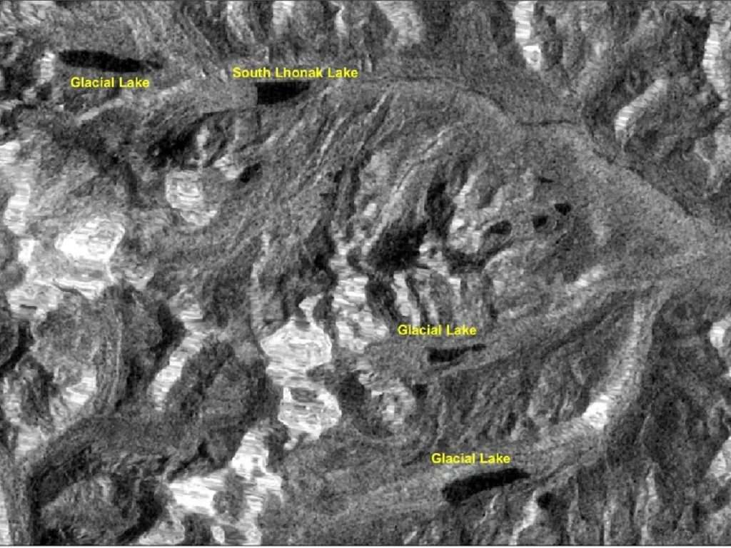
The apex disaster management authority further said that nearly 25 glacial lakes in Sikkim are assessed to be at-risk.
“While scientists are investigating the exact cause of the flash flood, the primary reason for the sudden surge appears to be a likely combination of excess rainfall and a GLOF event at South Lhonak lake in North Sikkim,” NDMA said in a statement.
Satellite images received from the National Remote Sensing Centre or NRSC at 6am on Wednesday reveal “the draining out of more than half the lake, most likely as a result of an avalanche from the ice-capped feature”, NDMA added.
“Highly vulnerable” to a GLOF event: SSDMA
According to a report by the Sikkim State Disaster Management Authority (SSDMA) compiled in 2019 highlights that in 2013, the scientists from the National Remote Sensing Centre in Hyderabad reported that at a height of 5,245 metres above sea level-the Lhonak Lake was “highly vulnerable” to a GLOF event, which were capable of causing extensive damage to life and property in downstream areas.
The report had warned of the possibility of “flash floods” which could damage dams power houses and other infrastructure.
It has said, “Townships like Chungthang, Dikchu, Singtam, Rangpo are vulnerable. Loss of life and property likely.”
Difference between GOLF and cloudburst?
GLOF stands for Glacial Lake Outburst Flood. It is the sudden release of a large amount of water from a glacial lake, often triggered by the collapse of a glacier or the melting of ice due to climate change. These floods can cause destruction, causing significant damage to infrastructure and posing a threat to human life in downstream areas.
A cloudburst is a sudden and intense rainfall event that occurs when a large amount of condensed water vapour in the atmosphere is released rapidly. This results in heavy rainfall over a short period of time, leading to flash floods and landslides. Cloudbursts can be particularly devastating in hilly or mountainous regions, where the rapid flow of water down slopes can cause significant damage to infrastructure and pose a threat to human life.
ISRO releases satellite images
According to the satellite pictures released by the Indian Space Research Organisation (ISRO), it compared images from September 17 and 28 which clearly show the drastic changes in the lake’s water volume. The images also reveal that the bullet-shaped lake originally held 162.7 hectares of water on September 17 and increased to 167.4 hectares on September 28.
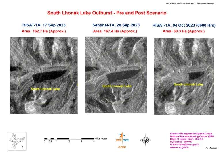
It also shows major changes on October 4 after the cloudburst and flash floods, with a picture showing the lake’s water volume declined to an estimated 60.3 hectares of area.
“Temporal changes in the lake area – as on September 17, September 28, and October 4. It is observed the lake is burst and about 105 hectares has been drained out, which might have created a flash flood downstream… will continue monitoring the lake using the satellite data,” the space agency said on its official website.
Also Read: Meghalaya on Orange Alert! Heavy rainfall, thunderstorm most likely in WGH and SGH
Also Watch
Find latest news from every corner of Northeast India at hubnetwork.in, your online source for breaking news, video coverage.
Also, Follow us on-
Twitter-twitter.com/nemediahub
Youtube channel- www.youtube.com/@NortheastMediaHub2020
Instagram- www.instagram.com/nemediahub

