

Shillong, May 1: Once a lush mosaic of dense tropical vegetation, the East Khasi Hills in Meghalaya are now facing a mounting environmental crisis. Over the past two decades, this district—home to iconic landscapes like Cherrapunji and Mawsynram—has experienced a significant decline in forest cover, driven largely by urbanization, shifting agriculture, and infrastructure development.
A study by researchers Parimita Saikia, Dariki S. Langshiang, and Lovely Raliang paints a stark picture. Using satellite imagery and advanced modeling techniques like the Cellular Automata–Artificial Neural Network (CA–ANN), the team tracked land use and land cover (LULC) changes from 2002 to 2022 and projected scenarios for 2030 and 2040. Their findings reveal that East Khasi Hills is on a trajectory of continuous forest loss, with dense forest cover predicted to shrink from 51% in 2022 to just 41% by 2040.
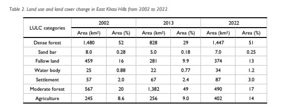
Between 2002 and 2013, dense forest area declined sharply from 1,480 km² to 828 km², driven by extensive deforestation, logging, and land conversion. Though a partial recovery to 1,447 km² was noted in 2022—likely due to conservation efforts—the broader trend remains worrisome. The study attributes these changes to a combination of anthropogenic pressures, particularly the growth of settlements and agricultural lands.
Urban expansion, especially around Shillong—the district’s rapidly growing urban center—has been a major driver of forest degradation. Settlement areas increased from 57 sq km in 2002 to 87 sq km in 2022, and are projected to balloon to 175 km² by 2040. This growth correlates with infrastructure development and rising population density, which together exert increasing pressure on forest ecosystems.

Moderate forests have also undergone significant transformation. Initially, these areas increased—likely reflecting the degradation of dense forest into secondary growth—but then declined again by 2022, highlighting ongoing degradation. In parallel, agricultural land surged from 245 sq km in 2002 to 402 sq km in 2022, primarily due to shifting cultivation and land reclamation efforts. Fallow lands, meanwhile, shrank by 85 sq km, indicating more land is being brought under active use.
The study also utilized the Normalized Difference Vegetation Index (NDVI) to assess vegetation health. Results showed a steady increase in non-vegetated and sparsely vegetated areas—from just 37 sq km in 2002 to 543 sq km in 2022. In contrast, highly vegetated zones (high and very high NDVI) declined by over 70% during the same period. These trends underscore the alarming pace at which green cover is being lost.
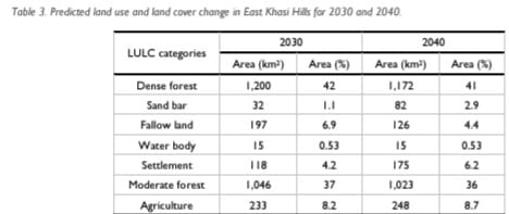
The CA–ANN model simulations for 2030 and 2040 show a grim future unless corrective measures are taken. Forest cover will likely be further converted into settlements and infrastructure, driven by tourism and land demand. Areas like Mawsynram and Cherrapunji, popular with tourists, are already witnessing drastic land use changes.
The implications of this forest decline are far-reaching. Beyond the obvious loss of biodiversity and ecosystem services, deforestation in East Khasi Hills threatens water security, increases vulnerability to landslides, and exacerbates local climate changes. The region, known for its rich ecological and cultural heritage, stands at a crossroads.
To reverse or at least slow this trend, the researchers advocate for stronger policy interventions that integrate land use planning with forest conservation. They stress the need for real-time monitoring, community-based forest management, and sustainable tourism practices that do not compromise ecological integrity.
Also Read: Abducted construction worker killed in encounter in Arunachal
Also Watch
Find latest news from every corner of Northeast India at hubnetwork.in, your online source for breaking news, video coverage.
Also, Follow us on-
Twitter-twitter.com/nemediahub
Youtube channel- www.youtube.com/@NortheastMediaHub2020
Instagram- www.instagram.com/ne_media_hub
Download our app from playstore – Northeast Media Hub

