
Guwahati, Nov 16: In a major scientific breakthrough for the Eastern Himalaya, a joint team from the National Centre for Polar and Ocean Research (NCPOR) and the Centre for Earth Sciences & Himalayan Studies (CESHS) has become the first research group to reach and study Dharkha Tso — a glacial lake flagged as high-risk for potential outburst floods (GLOFs) by the National Disaster Management Authority (NDMA).
The landmark achievement was part of the 4th Khangri Glacier Scientific Expedition 2025, carried out from November 8 to 14 in the remote Mago Basin of Arunachal Pradesh’s Tawang district. The annual expedition is a flagship programme aimed at strengthening long-term monitoring of glacier health, climate change impacts, and hydrological changes in the Eastern Himalayan cryosphere.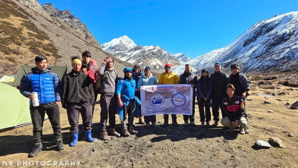
This year’s team included 11 scientists and engineers from CESHS, NCPOR (Goa), Nagaland University, and NERIST, Nirjuli. The mission was led by veteran glaciologist Dr. Parmanand Sharma (Scientist F, NCPOR) and coordinated by Er. Nyelam Sunil, who heads the Cryosphere Division at CESHS.
Despite heavy snowfall that prevented the team from conducting certain on-ground measurements, researchers successfully used advanced drone platforms equipped with high-precision sensors to map the Khangri Glacier and the cluster of Rani Lakes in high resolution.

A major scientific highlight was an unmanned sonar-based bathymetric survey of Rani Lake, which revealed aquatic life thriving at a depth of 20 metres — a rare discovery for such a high-altitude glacial ecosystem.
The team also retrieved crucial summer-season data from an Automatic Weather Station (AWS) and an Automatic Water Level Recorder (AWRL), and conducted round-the-clock discharge measurements downstream of the glacier to study meltwater behaviour.
The most significant achievement of the expedition was the first known scientific scaling of Dharkha Tso, one of the 29 glacial lakes in Arunachal Pradesh categorized by NDMA under Category B for GLOF risk.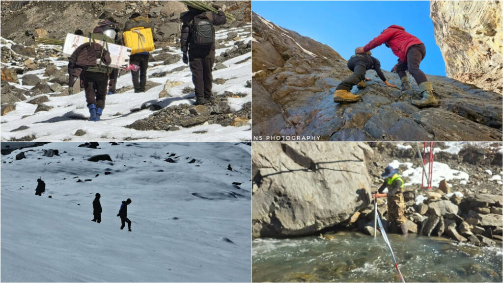
Perched at 16,145 ft (4,921 m) in the isolated Mirathang Valley, Dharkha Tso is inaccessible by any direct route. The team trekked 3.8 km from the Mago Chu river, climbing 1,710 ft over nearly five hours through more than 3 ft of fresh snow across a 700-metre stretch, dangerously low oxygen levels, steep ridges and gorges and narrow, slippery trails shaped by recent snowfall.
Braving these hostile conditions, the team carried out the first aerial drone survey, along with water and sediment sampling — critical steps toward evaluating the lake’s stability and potential GLOF hazards.

The successful conclusion of the 4th Khangri Glacier Expedition marks a major stride in India’s efforts to build a scientific foundation for Himalayan risk mitigation. The data collected will support deeper insights into glacier mass balance, meltwater contributions, hydrometeorological trends, and the evolving vulnerability of glacial lakes.
CESHS has expressed gratitude to the Government of Arunachal Pradesh, NCPOR, Nagaland University, and NERIST for facilitating this crucial mission in one of the Himalaya’s most challenging terrains.
Also Read: Notorious drug trafficker injured in police firing in Barpeta
Also Watch
Find latest news from every corner of Northeast India at hubnetwork.in, your online source for breaking news, video coverage.
Also, Follow us on-
Twitter-twitter.com/nemediahub
Youtube channel- www.youtube.com/@NortheastMediaHub2020
Instagram- www.instagram.com/ne_media_hub
Download our app from playstore – Northeast Media Hub

 and the Centre for Earth Sciences & Himalayan Studies (CESHS) has become the first research group to reach and study Dharkha Tso — a glacial lake flagged as high-risk for potential outburst floods (GLOFs) by the National Disaster Management Authority (NDMA).)