

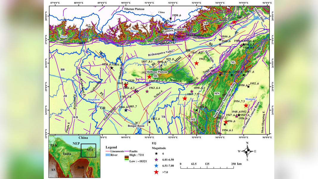

Guwahati, Dec 22: A major new seismic study has produced the most complete earthquake catalog ever assembled for the Shillong Plateau, offering fresh insight into one of the world’s most active earthquake zones and raising expectations for sharper hazard forecasting across the Northeast.
Authored by Mohd Shahabuddin and Prof. William Kumar Mohanty of IIT Kharagpur, the research — published in Seismological Research Letters (2025) — compiles 6,877 earthquakes of magnitude 3.5 and above, dating back nearly 1,200 years to 825 CE. The Shillong Plateau and adjoining areas, including much of Meghalaya, fall within the study zone.
The Shillong Plateau (SP) of northeastern India is one of the world’s most seismically active regions, primarily due to the ongoing collision of the Indian–Eurasian plates to the north and the Indian–Burmese plates to the east, which began approximately 60 million years ago. It has experienced many major to great earthquakes in the past, such as 825 earthquakes of magnitude M 8; 1787, seismic moment magnitude (Mw) 7.8; 7.1 Meghalaya earthquake, 1950 Mw 8.5 Assam earthquake, and so on.
The SP is demarcated by the Dauki fault in the south, the Dhubri fault in the west, the Dhansiri–Kopili fault in the northeast, and the Oldham fault in the east, which make it capable of producing large to great earthquakes
The Shillong Plateau region remains highly active due to ongoing tectonic collision along the Indian–Eurasian and Indian–Burmese plate boundaries.
Scientists say the unified catalog could improve seismic risk planning as the region continues to experience regular tremors and expanding infrastructure development. The Plateau has produced some of India’s most destructive earthquakes, including the 1897 Shillong (Mw 8.1) and the 1950 Assam (Mw 8.5) quakes, which caused more than 3,000 deaths combined.
The researchers standardised multiple datasets and corrected long-standing inconsistencies by introducing 30 new magnitude conversion relationships to unify all events under the moment magnitude scale (Mw). They also removed aftershocks and foreshocks to isolate 4,134 mainshock events, helping identify more accurate seismic patterns.
According to the authors, the catalog strengthens “completeness analysis” — showing that reliable records for major earthquakes (Mw 6.5 and above) now extend back nearly 200 years.
Officials and planners are expected to look closely at the findings as Meghalaya and neighbouring states push ahead with major investments in roads, town expansion and hydropower projects.
The authors say the updated catalog will support more robust hazard mapping, modelling and risk assessment — a key requirement for strengthening earthquake preparedness across the region.
Also Read: Meghalaya govt releases Rs 1,603 Cr to boost festive spending and clear dues
Also Watch
Find latest news from every corner of Northeast India at hubnetwork.in, your online source for breaking news, video coverage.
Also, Follow us on-
Twitter-twitter.com/nemediahub
Youtube channel- www.youtube.com/@NortheastMediaHub2020
Instagram- www.instagram.com/ne_media_hub
Download our app from playstore – Northeast Media Hub